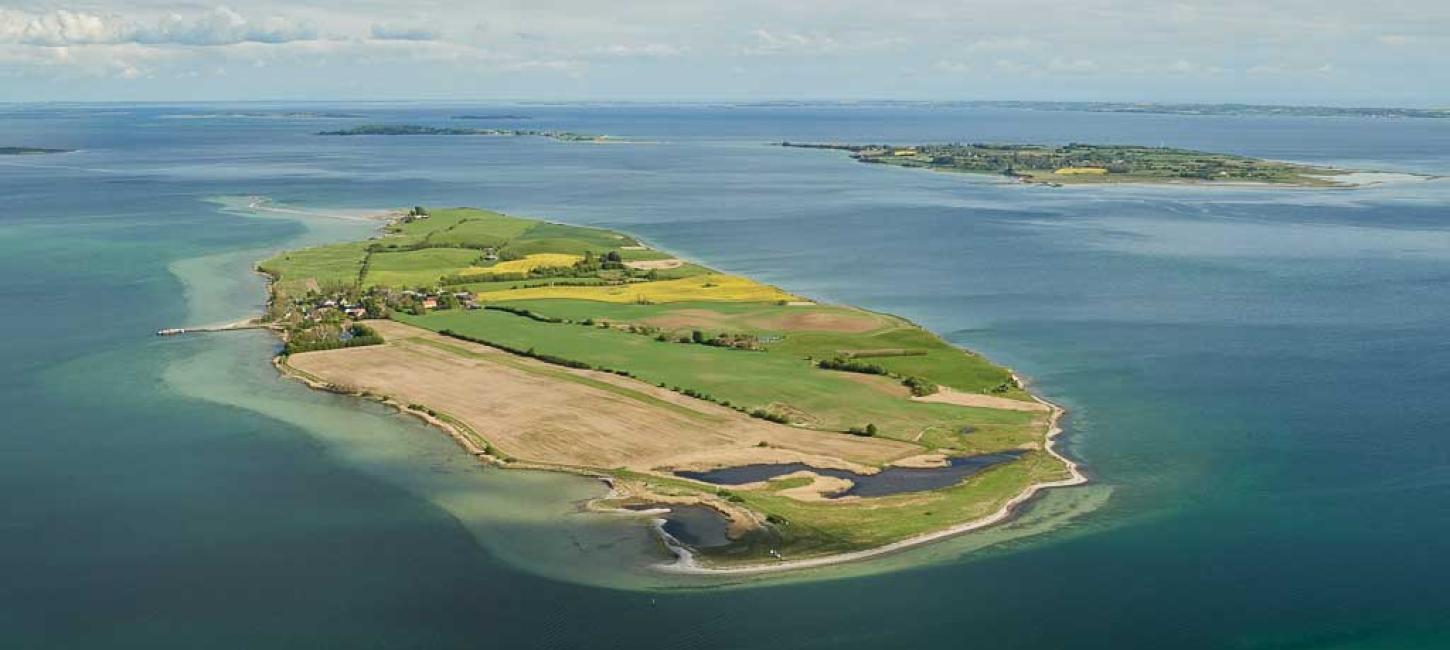
Bjørnø
Bjørnø is a hilly island, peaking at Højberg (24 m above sea level), with plenty of great options for swimming and fishing.
You get to Bjørnø by taking the ferry ‘M/F Lillebjørn’, which departs from Faaborg several times a day. The crossing takes only 17 minutes, making it an easy commute for those of Bjørnø’s residents who work on Fyn. This in turn means that the island’s population has been stable for the past 20 years.
Bjørnø has a café which is open from May to September as well as a number of accommodation options, including a primitive campsite. There are no forests on Bjørnø, although there is some vegetation north of the fen area in the central part of the island, which is adorned with rolling hills and picturesque stone fences. Large colonies of sand martins live in the island’s southern cliffs. The spit formation called Holmene is a breeding site for the common gull, and visitors are asked to avoid the area between 1 March and 15 July.
The first written mention of Bjørnø is from the 13th century (with the spelling ‘Byørnø’), and up until the 20th century, the island had a single owner – first the Danish king, and later the estate of Holsteenshus on Fyn.
Throughout history, Bjørnø has been connected with the art of smuggling. In the 18th century, the residents of Bjørnø had ongoing feuds with the authorities. In 1752, a customs boat was sent from Faaborg to put an end to the smuggling, but when the officers set foot on Bjørnø, they were promptly thrown out. Then, when the male islanders were away, the customs officers returned and took out their revenge on the women and children. The case went to court, and not only were the islanders awarded financial compensation, but the ruling also cleared the residents of the smuggling charge.
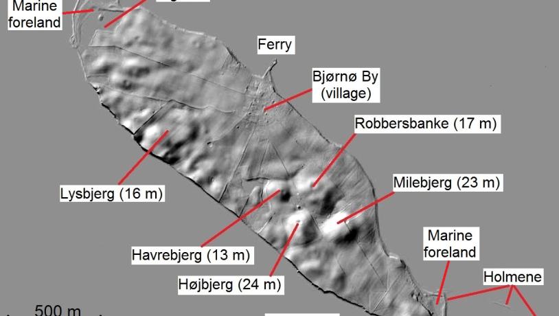
Photo:-
The Glacial Landscape of Bjørnø
There are several reasons for Bjørnø’s geological significance. Firstly, the island has the same oblong shape as Avernakø and Ærø, orientated southeast-northwest, and thus reflecting the flow direction of the last ice advances of the Weichselian glaciation.
Secondly, Bjørnø is quite hilly relative to its small size. When the last ice advance stagnated and the dead-ice started melting, several water-filled hollows emerged on the surface of – or between – the melting ice masses. These hollows were filled with meltwater sediments, and when the ice had melted away, the filled-up hollows remained as hills. Such hills – which constitute some of the highest points on Bjørnø today – are known as kame hills. Some of the lowest points on the island have become fens and ponds.
A hike along the cliffs on the southern coast of Bjørnø offers a glimpse into the island’s geological past – sediments from at least three separate Weichselian ice advances are visible. The oldest moraine clay was deposited during the Ristinge Ice Advance (55-50,000 years ago). The following deposits date from the Main Weichselian Ice Advance (23-21,000 years ago) and from the Young Baltic Ice Advances (19-17,000 years ago). You might also see thin layers of marine clay with mollusc shells (known as ‘Cyprina Clay’) from the last interglacial period, the Eemian (130-115,000 years ago) – clay, which the glaciers have ‘kneaded’ into the ice-age layers.
The Dynamic Coastal Landscape
Since the sea flooded the area south of Fyn, creating the South Fyn Archipelago, Bjørnø’s glacial landscape has been eroded. This process is still ongoing, especially along the southern coast, where the sea opens up towards the island of Als, 18 km to the southwest. All along the southern coast, the forces of the sea have formed a striking stretch of cliffs. Such a relatively straight coastline on which protruding elements have been eroded and bays have been filled up is called a simplificated coast. Long-shore currents transport loose clay, sand, and gravel to the northern and southern tips of the island. In the calmer waters there, the material is deposited, thus creating new land: marine foreland.
The 700 m long straight spit known as Holmene at the southeastern end of Bjørnø is the island’s most significant young coastal landscape. The spit has formed as an ‘appendix’ to the marine foreland with the help of three small ‘anchoring points’ - remnants of the inundated glacial landscape - which protruded ever so slightly from the shallow waters.
The water is deeper at Bjørnø’s northwestern end where the marine foreland known as Digerne is located: a salt meadow with several smaller beach lakes. Originally, these lakes were open lagoons, but they were eventually tied off by sandy and gravelly beach ridges, formed by the sea. The outermost lagoon is occasionally tied off from the sea by small, recurved spits. From looking at old maps, we can gather that Bjørnø’s young coastal landscapes have formed within the last 200 years.
Longitude: 10.250244
Latitude: 55.061855