Bregninge Kirkebakke
The highest hill in the South Funen Archipelago with Bregninge Church on top offers stunning views of part of the Geopark and opportunities for short hikes
Longitude: 10.610057
Latitude: 55.023514
Bregninge Kirkebakke (Bregninge Churchhill) on northern Tåsinge is widely visible and, at almost 74 m, is the highest point in the South Funen Archipelago.
The hill is crowned by Bregninge Church, whose history dates back to a boulder church from the 1100s. Before that, there may have been an even older wooden church, but the evidence is lacking as no excavations have ever been carried out on the site. Since then, the church has undergone numerous additions and rebuilds, and today, older parts of the building are mostly visible in the interior of the church. The granite baptismal font and a beautiful coffin-shaped granite tombstone with a rune inscription, both in Romanesque style, can be traced back to 1150-1250 AD. The church's current appearance is the result of a thorough restoration in 1882-83, which included raising the tower and giving it its current spire.
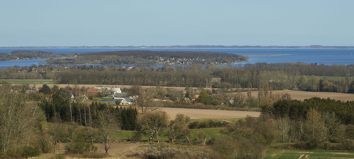
The church is a popular vantage point and a well-known landmark. From the church tower you have one of the Geopark's most beautiful views, with Tåsinge, Svendborg and large parts of the South Funen Archipelago spread out at your feet. On clear days, you can see as far as Zealand and Kiel in northern Germany, and it is said that you can see 28 islands, 65 churches and 20 castles. This has made the church one of the most visited in Denmark with up to 50,000 visitors annually.
Parking is available at the church. Directly opposite is the protected Bregninge Bakker with a former sand pit and two half-timbered houses that house the Tåsinge Museum. Within walking distance from the church you will find the privately owned, but publicly accessible, hilly grassland landscape, Løkkekærs Banke - also known as the 'Casanova hills'.
If you want to experience the entire landscape of Bregninge Kirkebakke, a bicycle or car is recommended.
The ice age landscape at Bregninge Kirkebakke
Bregninge Kirkebakke's oval shape (5.5 x 2.5 km), its imposing size and unique location have contributed to the debate about its formation history. Most likely, it is an ice-marginal hill, where several ice advances may have contributed to its formation. However, the hill does not appear to represent an actual ice margin, as there is no evidence of a continuation of such a line in the adjacent landscape.
The interior of the hill consists mostly of frequently alternating layers of meltwater deposits and moraine clay. However, there are also layers of the more than 53,000-year-old water- and wind-deposited 'White Sand', layered meltwater clay deposited in ice-encircled lakes, and more than 42 million-year-old 'plastic clay' between the glacial layers. This suggests that the hill's core is made up of layers that have been pushed up, folded and pushed over each other by one or more glacial advances.
Prior to the last ice flows of the last ice age, the Weichselian (115-11,700 years before present), a smaller hill created by an older ice advance may have already existed. This hill may have been subsequently overrun by several ice streams, each of which pushed the hill further and even deposited new material over it, increasing its size and height.
The melting of the last glacier in the area, the Bælthav Ice Stream (18-17,000 years before present), occurred in several stages, interrupted by a series of re-advancements where the ice briefly advanced again. One of these re-advancements may have pushed Bregninge Kirkebakke (from the southeast) one last time, giving the hill its final shape and creating the curved, parallel ridges of sand and gravel that make up the highest parts of the hill.
From the summit at the church, the rolling landscape slopes down towards the coasts. At levels around 40-50 m above sea level, several small and short valleys are eroded into the slopes. Supposedly, they are caused by water erosion from springs that bubble up from the ground in connection with water-leveling clay layers inside the hill. Today, most of the valleys are dry.
A good place to experience the landscape is Løkkekærs Banke ('Casanova Hills'), 200 m northwest of Bregninge Church. The name comes from the former dance establishment 'Casanova' in Gerritsgade in Svendborg, whose charismatic owner, Niels Christoffer Sørensen, once owned Løkkekærs Banke.
The sandy, open terrain lies on the west side of the highest hill ridge as a dry grassland - poor in nutrients but rich in plants. The area is grazed by animals. It is one of the few places in Svendborg Municipality with heather heather. From the top of the 64 m high hills there are great views. The small lake, Lyngkær, below the hills gets part of its water from a spring.
On the north side of Bregninge Kirkebakke is Ingers Høj, a burial mound from the early Bronze Age. It measures 41 m in diameter and 7 m in height and is one of the largest of its kind in Denmark. The mound is a good vantage point.
Utilization of the geological resources
Meltwater sand and the characteristic quartz-rich 'White Sand' have been exploited in several sand pits on Bregninge Kirkebakke from before 1842 and into the 1990s. Today, most of the former quarries are overgrown or have been completely restored.
The landscape in the future
As a single location, Bregninge Kirkebakke covers a relatively large area of approx. 11 km2 calculated from an elliptical basic shape of approx. 5.5 x 2.5 km. It should be noted that the lower, flatter parts of the hill are not included. From a geological perspective, the glacial landscape on the hill and the adjacent areas will hardly change significantly in the foreseeable future due to its size alone.
However, increased precipitation could generally affect the groundwater level and runoff conditions on the hill and locally raise the water level in depressions, small lakes and bogs. The area's springs could also become more water-rich. Whether this will be sufficient to reactivate some of the springs in the erosion valleys in the 40-50 m level on the hill is unclear.
Increased precipitation also influences the natural soil-forming processes and could, for example, lead to increased leaching of clay, salts, minerals and nutrients from the upper soil layers. For example, leaching and natural soil formation in the nutrient-poor and acidic sandy soils on the ridges of the small forest north of Bregninge Mølle has led to incipient but clear podzolization of the top 50 cm of soil. This area was previously home to coniferous trees, which contributes to the natural acidification of the upper soil layers.
Large parts of the surface layer of Bregninges Kirkebakke consist of moraine clay and are covered with vegetation and/or cultivated, which overall inhibits erosion by surface runoff of rainwater.
However, on sandy soils with a thin plant cover in a steeply sloping terrain, more frequent cloudbursts and/or generally more precipitation can cause erosion of the upper soil layers. This is sometimes seen (on a small scale) on some of the sandy soils on the higher, steep parts of the hills in early spring when crops are not yet growing in the fields. In such places, soil fumigation has also been observed during prolonged spring droughts.
Value
Bregninge Kirkebakke and the church serve as a well-known landmark in the area. Due to the beautiful views, the church is one of the most visited in Denmark with approximately 50,000 visitors annuallyd. The hill itself is of particular geological interest due to its exciting history, which does not yet seem to be fully clarified.
Some of the areas adjacent to the church, including one of the former sand pits, have been protected since 1919 through several conservation orders, including §3 of the Conservation Act. This also includes the privately owned area, Løkkekærs Banke, with the valuable dry, sandy and nutrient-poor grassland areas with interesting plant communities with over 100 described plant species. The small lake, Lyngkær, is home to several species of amphibians, and on the sun-exposed hillsides, field lizards (Lacerta agilis) have previously been released.