Thurø Smørmose
Coastal cliff with deposits from two ice ages, a plant-bearing deposit from an interglacial period, soil layers with permafrost structures and a nearby beach
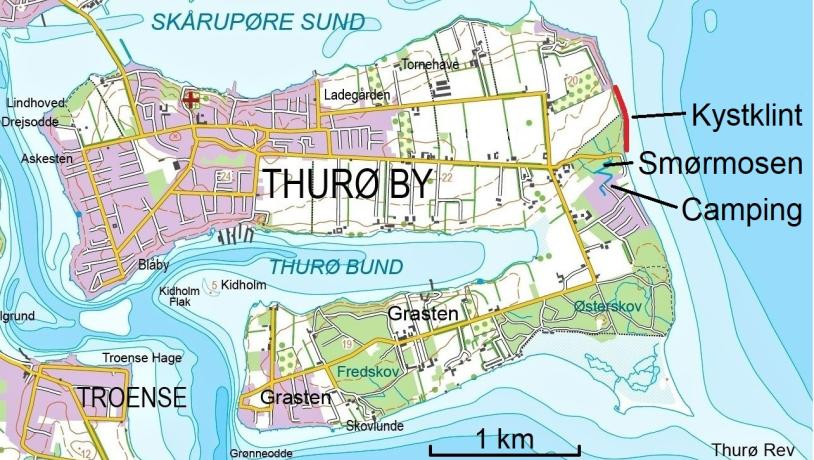
Thurø Smørmose, or simply Smørmosen, (Thurø Butter-bog) is located on the east coast of Thurø and is a well-known recreational area - not so much because of the cliff, but because during the summer months it is home to one of the island's best beaches. The area is easily accessible from the cozy parking lot under the beech trees in Smørmose forest at the end of Gyldenstensvej just north of Thurø Camping (Thurø Strand Camping).
By going left (north) along the beach next to the parking lot, you'll immediately reach the southern end of Smørmose cliff, which is 510 m long and up to 12 m high. A long stretch midway with slides and scrubs divides the cliff into a southern and northern half, the latter being the most interesting.
If you want to see as much geology as possible, it is recommended that you visit the site during the winter months, when storms and high tides have created fresh cuts in the geological layers and removed slipped material. This is also the time of year when there are usually the most rocks on the beach, as much of the sand has been washed away by the waves. Here you can find specific erratic boulders, (stones which lithological origin can be traced back to the parent bedrock.) from both central and southern Sweden, as well as from the Baltic Sea regions.
The ice age landscape at Thurø Smørmose
The hinterland of the two cliff sections is an even moraine surface without significant differences in elevation. The layers of the cliffs lie neatly on top of each other and, as one of the relatively few places in the archipelago, have not been folded or otherwise disturbed during the glacial transgressions of the ice ages.
In the southern half of the cliff, gray moraine clay deposited by the 'Northeast Ice' 23-21,000 years ago during the last ice age, the Weichselian. Above this is brownish moraine clay from one of the last Weichselian ice advances - possibly from the part of the Bælthav Ice Stream known as the 'Great Belt Glacier' (18-17,000 years before present). This moraine deposit also forms the surface layer of the moraine surface and thus most of Thurø. In some places, reddish streaks and bands can be seen in the upper moraine clay. The color is caused by crushed and rolled red sandstone from the Cambrian period (541-485 million years before present).
In the northern and most exciting half of the cliff, the sequence begins at the bottom with two layers of blue-gray moraine clay. Both layers possibly date from the younger part of the 'third-last ice age', the Elster Ice Age (480-424,000 years before present). The lower of these two layers can also be seen at Thurø Østerskov (Thurø Eastern forest)
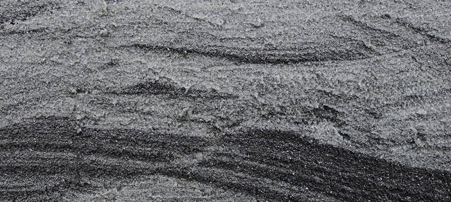
Above this is 1.5 m of gray, layered clayey sand with numerous black streaks of organic material that make the deposit look like striped licorice confectionery. In the upper part, the layering is in the form of flat bowls, so-called trough cross bedding. The sand contains plant remains and pieces of wood, indicating that it is a freshwater deposit from an interglacial period.
At the top, this deposit ends with a bluish clay layer with scattered stones - probably a lake deposit, where the stones may have been dropped from melting winter ice. The stones are therefore also called dropstones.
Above this is more than 2.5 m of light, quartz-rich, gravelly sand, whose structures show that it was deposited by flowing water running south. At the top of the sand there are traces of an ancient land surface, where the upper soil layers have 'curled around' as a result of repeated thawing and freezing of the layers in an Arctic environment characterized by permafrost. Such 'curling' structures are called cryoturbations and are relatively rare in this part of the country. The quartz sand is similar to the so-called 'White Sand', which was deposited more than 53,000 years ago in the middle of the last ice age and is known from several locations around the Geopark.
At the top of the cliff, the layer series ends with a 1 m thick layer of meltwater sand and 1.5 m of brownish moraine clay, of the same type and age as seen at the top of the southern half of the cliff.
The dynamic coastal landscape
Since the sea in the Holocene (the period after the last ice age) invaded the area south of Funen and created the South Funen Archipelago, Thurø's glacial landscape has been gnawed away. Among other things, this led to the formation of the coastal cliff north of Smørmosen. From here, some of the loosened clay, sand and gravel was carried south by the coastal current to the small bay at Thurø Camping, where the material was deposited and built up a narrow strip of new land - so-called marine foreland. Today, this is the popular bathing beach.
At the edge of the current campsite, after the formation of the archipelago, there was a narrow strait across Thurø that divided the island into two parallel islands. Later, the strait became a depression cut off from the sea and filled with various lake and bog deposits - the area we know today as Smørmosen.
The nature of the beach next to the cliffs changes with the seasons, but in the winter months it is often covered with stones that the sea has washed out of the moraine layers over time.

Photo:GDSØH
The landscape in the future
The site basically consists only of the coastal cliff itself and the beach below, and is therefore of limited extent. From a geological perspective, the underlying glacial landscape is unlikely to change in the foreseeable future.
However, increased precipitation will affect the groundwater level and runoff conditions on the clayey moraine surface and locally raise the water level in local depressions, which is detrimental to cultivation areas with low-lying soils and low-lying properties.
This also applies to the areas currently covered by Smørmose Skov, where soil conditions can change due to, for example, temporary water damming and the formation of so-called pseudo-gley in the upper soil horizons. In the long term, this will affect the choice of tree species in future forestry.
In addition, more precipitation will probably also lead to increased groundwater seepage along the surface of the lower moraine layers in the cliff base, which is already a controlling factor for landslide processes in the northern half of the cliff. This, in conjunction with increased coastal erosion in connection with future sea level rise, storm surges and high water situations, could, all things being equal, lead to more and more frequent landslides resulting in loss of land. However, it should be added that, under the right conditions, there may also be (possibly periodic) increased sediment input towards the coast. How this balance will develop in the future is not known with certainty.
The majority of the underlying moraine landscape is vegetated and/or cultivated, which, together with the clay surface layers and very limited terrain slopes, is unlikely to lead to significant changes in surface erosion, even with an increasing frequency of cloudbursts.
Thurø once formed two separate islands, separated by a narrow strait through the low-lying area of Smørmosen. A water level rise of 1.7 m and above will restore this condition.
Value
Together with the cliff at Thurø Østerskov, the Smørmose cliff plays an important role in the investigation of the local and regional Quaternary geological development history, where the presumed Elster deposits and the organic-rich freshwater sediments of interglacial origin are of particular importance. In addition, the presence of the old land surface with periglacial cryoturbation structures in the northern cliff profile also helps to shed light on the paleoclimatological conditions during the Weichselian.
The cliffs at Smørmosen and Østerskov are among the few selected sites within the Geopark that apparently have a low degree of glacial tectonic deformation, i.e. disturbances of the layers caused by moving glaciers. All in all, the cliff at Smørmosen is an obvious site for future scientific studies.
The Thurø Smørmose cliff has recently been classified as a site of regional geological interest (RGI).
Longitude: 10.709766
Latitude: 55.050372