Skjoldnæs og Næbbet
Coastal cliffs, dead ice landscapes and a well-developed Holocene angular foreland are among the natural attractions on the northwesternmost part of Ærø
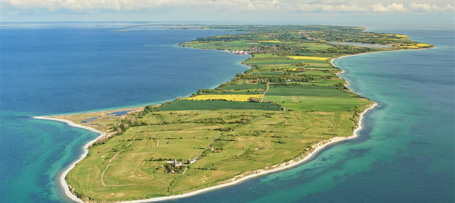
The 4.5 km long and 600-800 m wide Skjoldnæs Peninsula makes up the northwesternmost part of Ærø. Most of the peninsula is privately owned and cultivated, but out by the golf course and Skjoldnæs Lighthouse there is public access with parking and toilet facilities. From the top of the 22 m high lighthouse - built in Bornholm granite - there is a wide view of the area and you can see all the way to Germany, Als, Lyø, Bjørnø, Avernakø and the Funen Alps.
Small paths lead from the parking lot down to the beach. The characteristic seascape Næbbet is privately owned and can be reached via a short walk along the coast.
The ice age landscape on Skjoldnæs
The pronounced southeast-northwest orientation of Ærø and many of the island's elongated hills reflect the movement pattern of the youngest ice streams across Ærø within the period 19-17,000 years before present. The Skjoldnæs peninsula itself also appears to form the southern flank of an ice margin line that extends over towards Avernakø via a submarine arcuate threshold. The ice margin was created in connection with a minor re-advancement during the general retreat of the Bælthav ice stream ('Lillebælts glacier') from the area around 17,500 years ago, when the ice briefly advanced slightly. At Skjoldnæs, the glacier left behind immobile ice masses (dead ice), which, as the ice finally melted away, gave rise to the small hilly dead ice landscape.
The older history of the glacial landscape can be seen in the coastal cliffs. The oldest layers consist of fat, stoneless freshwater clay ('White Clay') and sea-deposited clay ('Cyprina Clay') with mussel shells - both from the last interglacial period, the Eemian (130-115,000 years before present).
Otherwise, the cliffs are dominated by moraine clay and meltwater deposits from three different ice advances during the last ice age, deposited 23-17,000 years ago. In some places, whitish, quartz-rich sand occurs, deposited more than 53,000 years ago by wind and water on floodplains in an Arctic environment characterized by permafrost.
From 1890 to 1925, Haven Brickworks, which employed 5-6 workers, was located near the settlement of Haven from 1890 to 1925. The brickworks exploited deposits of lime-poor clay and produced some of the best bricks on Ærø.
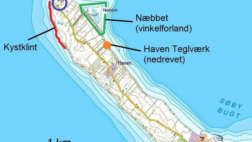
Photo:Illustration: Søren Skibsted
The dynamic coastal landscape
Since the sea invaded the area south of Funen and created the South Funen Archipelago, Skjoldnæs' glacial landscape has been gnawed away. Due to its exposed location, the peninsula's coasts have developed as steep coasts with an almost unbroken series of cliffs. Erosion is particularly pronounced along the southern coast, where there is 11 km of open sea to Als. In addition to the cliffs, the forces of the sea have created an almost rectilinear coastline where protruding points have been eroded away and smaller bays filled in. This is called an equalizing coast. The beaches are narrow and rocky. In several places, the waves have created massive pebble beach ramparts that provide some protection against erosion of the slopes by the sea.
The loosened clay, sand and gravel are carried by coastal currents to places with calmer water, where the materials are deposited and create new land - marine foreland.
On the northeast coast of the peninsula, opposing coastal currents have brought in materials from two sides, creating one of the archipelago's finest examples of an angular foreland, the Beak. The marine foreshore is shaped like a triangle and consists of salt marshes and large sea walls. The many water holes look natural, but are the result of extensive channel excavation between 1890 and 1975. The stone materials were used, among other things, for the construction of the Kiel Canal in northern Germany. In the 1930s, a special type of rounded flint (spherical flint) was used as crushed stone in cement and porcelain mills, and at one point there was both a shipping bridge and a tipper car track here. On Næbbet there are also remains of a military entrenchment from 1812.
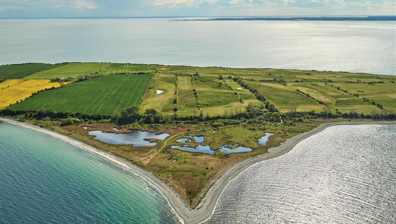
Photo:Mikkel Jézéquel
The landscape in the future
From a geological perspective, the glacial landscape at Skjoldnæs is unlikely to change in the foreseeable future. Apart from the human impact on the surface terrain, e.g. through normal farming, changes to the landscape are expected to be limited - also partly due to the area's somewhat remote location. The Skjoldnæs peninsula does not include any major landscape elements such as prominent hills (the highest hills are 27 m), which could be obscured by forestation. However, the characteristic, open, small hilly dead ice landscape will quickly lose its character through afforestation and in connection with the possible installation of wind turbines and large solar cell systems as part of the green transition.
Since the closure of Haven Teglværk in 1925, there has been no commercial extraction of raw materials in the area.
With the prospect of an expected rise in sea level and climate change, which is expected to increase the frequency of storms and high water situations, the degradation of the coast is likely to accelerate.
Two types of erosion are distinguished: (1) Chronic erosion, which is the daily wave, current and wind impact on the coast; (2) Acute erosion, which typically occurs during storms in combination with high tides and strong wave action. Severe acute erosion of cliffs, especially during storm surges, can cause landslides and loss of land. Similarly, increased precipitation will increase the risk of landslides. However, coastal locations should be kept free from coastal protection as far as possible so that natural coastal processes can continue to keep the profiles open.
A rising sea level could increase the risk of saltwater intrusion into coastal drinking water wells and/or aquifers.
In many places, the low-lying areas of the dead ice landscape contain small patches of moss and low-lying soils. Increased precipitation, together with rising sea levels, will affect the groundwater level and runoff conditions and locally raise the water level, potentially causing problems for properties and agricultural land.
As the terrain slopes are moderate and the surface soils are predominantly clayey, more frequent cloudbursts are unlikely to lead to significant changes in surface erosion.
Value
The outer part of Skjoldnæs with the golf course and the area around the lighthouse is a popular recreational area with a special "end of the world feel". From a geological and natural point of view, the cliffs are interesting, but the main attraction is the Holocene angle foreland, Næbbet. Despite the fact that trenching has left its mark on the landscape, the marine foreland with its salt marshes, beach embankments and small open water areas is still an interesting bio- and geotope.
Skjoldnæs and Næbbet are part of the international geosite Det Sydfynske Øhav (GS 5-2) and also belong to the National Geological Interest Area NGI 128 and the Coastal Landscape Interest Area NK 42. In addition, the southwest coast of Skjoldnæs borders the marine Natura 2000 area no. 197 and habitat area H173.
Longitude: 10.207313
Latitude: 54.96862