Vitsø
Former fjord cut off from the sea by a Holocene marine foreland with ancient trenches. Exciting natural and cultural history, as well as a coastal cliff with deposits from the Eemian, Saale and Weichselian ice ages.
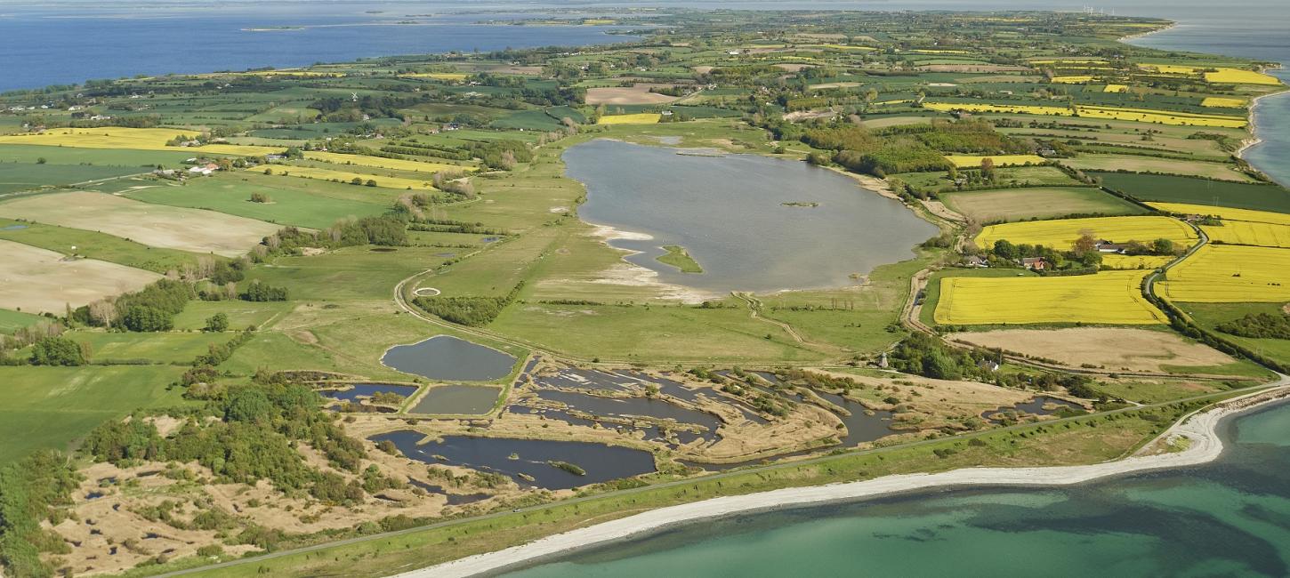
Vitsø is an exciting area a few kilometers south of Søby on northwestern Ærø, from where there is a ferry to Faaborg. Originally, Vitsø was an open fjord that stretched 2 km inland and until the early 1600s was navigable all the way to the medieval Søby Voldsted and Søbygård (built in 1580). Gradually, the sea deposited large amounts of sand, gravel and stones in the mouth of the fjord and in 1688 the fjord was almost cut off from the sea.
The connection to the sea was finally severed in 1788 when the owner of Søbygård built a dike along the coast, turning the fjord into a nor. In 1838, the Vitsø Pump Mill was inaugurated - a windmill that lifted ('screwed') the water up over the dike using a wooden archimedean screw. The purpose was to drain Vitsø Nor and turn it into farmland. However, this didn't really succeed until the 1950s and 60s with the help of a modern pumping system, new drainage channels and a new dike. Today, large parts of the Vitsø Nor area are below the current sea level.
In 2009, part of Vitsø Nor was recreated as part of a nature conservation and aquatic environment project to reduce nitrogen discharge to the Little Belt and thus reduce the risk of oxygen depletion. To help wildlife, artificial bird islands were established in the lake and extra amphibian holes were dug in the meadows.
Aage V. Jensens Fonde currently owns 114 hectares of the area, divided into 52 hectares of freshwater lake and 62 hectares of meadows. Several parking lots provide easy access to the area and marked trails with information boards lead visitors on a delightful 5 km walk around Vitsø Nor. In the northeast corner of the area there is a bird tower. On the southern slope down to Vitsø Nor is Vorbjerg Forest, which was planted in 1996. From Søby Volde you can enjoy the beautiful view of the area.
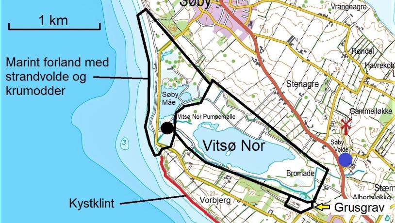
Kort over Vitsø området. Sort prik: Vitsø pumpemølle; Blå prik: Søby Voldsted.Photo:Illustration: Søren Skibsted
Vitsø Nor is located in a large valley whose formation history has not yet been fully clarified. It may be a meltwater valley or part of a tunnel valley created under the ice and/or a large dead ice-filled depression between the hills. Dead ice is glacial ice that is no longer moving. To the southeast, the 'Vitsø Valley' seems to be connected to a narrower valley that extends into the beautiful hilly dead ice landscape around Ærø's highest point, Synneshøj (68 m) - also known as the 'Ærø Alps'.
Between Vitsø Nor and the coast lies the hill Vorbjerg (31 m). The elongated shape of the hill reflects the direction of movement of the youngest Weichselian ice streams that slid up Ærø from southeast to northwest. Such a hill that the ice has 'pulled out' is called a drumlin.
The building blocks of the landscape can be studied in the 15 m high coastal cliff on the south side of Vorbjerg. The oldest deposit is gray moraine clay deposited about 140,000 years ago by the youngest ice advance in the penultimate ice age, the Saale (390-130,000 years before present). This is followed by 'White Clay' and marine clay with mussel shells ('Cyprina Clay') from the Eemian interglacial (130-115,000 years before present). The younger layers consist of 'White Sand' (deposited by wind and water in an Arctic climate characterized by permafrost), as well as till clay, meltwater sand and gravel deposited by 2-3 different glacial advances during the Weichselian period (115-11,700 years ago). The different glaciers have pushed the layers, so the sequence of layers in the cliff is not easy to understand.
The dynamic coastal landscape
During the Holocene (the period after the last ice age), when the sea invaded the area south of Funen and created the South Funen Archipelago, the 'Vitsø Valley' was flooded by the sea and turned into a 2 km long fjord arm. As the sea gnawed away at the cliffs of the surrounding glacial landscape, the loosened clay, sand and gravel was carried by coastal currents to places with calmer water, where the materials were deposited and created new land - so-called marine foreland. In the mouth of the fjord, a large system of seawalls and groynes was built up, slowly cutting off the fjord from the sea. Today, most of this system of headlands, called Søby Måe, has unfortunately been destroyed due to past dredging.
On the seaward side of the dike, you can see large rocky sea walls created by the waves during storms and high tides. In the northernmost part, there is a small area of drifting sand and small dunes. Below Vorbjerg, the beach is narrow and rocky with scattered large boulders washed out by the glacial layers by the surf.
Exploitation of geological resources
The beach embankment and crumbling dune system with salt marshes and ponds (Søby Måe) is clearly visible on shadow maps and older aerial photos. Unfortunately, most of the system is now destroyed due to earlier, more or less unregulated trenching. Remnants of this local 'Klondike' are still visible in the form of the water-filled trenches, in places with barren rocky islets and islets.
At Sellebjerg at the southeastern end of Vitsø Nor is a small privately owned gravel pit (without public access) in a small area of shallow meltwater sand and gravel. Gravel pits have existed at this location since at least 1842.
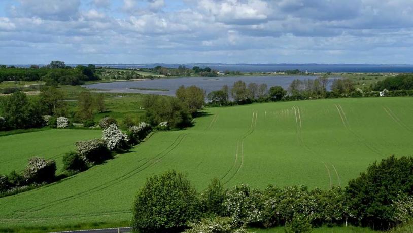
Photo:Søren Skibsted
The landscape in the future
From a geological perspective, the glacial landscape around Vitsø Nor is unlikely to change in the foreseeable future. Apart from the human impact on the surface terrain, e.g. through normal agricultural operations, changes to the landscape are expected to be limited. However, the landscape will lose character with further afforestation, the installation of wind turbines and the establishment of larger solar cell installations as part of the green transition.
With the prospect of an expected rise in sea level and climate change, which is expected to increase the frequency of storms and high water situations, coastal degradation is likely to accelerate.
Two types of erosion are distinguished: (1) Chronic erosion, which is the daily wave, current and wind impact on the coast; (2) Acute erosion, which typically occurs during storms in combination with high tides and strong wave action. Severe acute erosion of cliffs, especially during storm surges, can cause landslides and loss of land. Similarly, increased precipitation will increase the risk of landslides.
The coastal cliff below Vorbjerg is particularly exposed to landslides controlled by precipitation, groundwater seepage, sea erosion and, not least, the geological conditions where the cliff contains ice-disturbed layers of fat clay (primarily 'Det Blanke Ler' and 'Cyprina Ler' from the Eemian interglacial period). Such layers act as water levels and soap-covered sliding surfaces, on top of which the overlying soil layers slide out.
However, as part of the preservation of the geopark's natural characteristics and geodiversity, the cliffs and other coastal stretches should be kept free of coastal protection as far as possible, so that the natural coastal processes can continue to operate freely while keeping the illustrative geological profiles open.
A rising sea level will potentially increase the risk of saltwater intrusion into coastal drinking water wells and/or aquifers.
Due to the morphology and formation history of the area, the surrounding moraine landscape contains relatively few depressions with small areas of moss and low-lying soils. However, increased precipitation together with rising sea levels can affect groundwater levels and runoff conditions and locally raise water levels, potentially causing problems for properties and farmland in the area.
As the terrain slopes are relatively moderate and the surface soils are predominantly clayey, more frequent cloudbursts are unlikely to lead to significant changes in surface erosion. However, the northern side of the 'Vitsø valley' is in places furrowed by small, short erosion valleys that give parts of the terrain the character of false hills. These erosional valleys are considered to have been created at the end of the Weichselian and/or early Holocene.
Most of the surrounding glacial landscape is otherwise cultivated and/or wooded.
Increased precipitation also influences the natural soil-forming processes and could, for example, lead to increased leaching of clay, salts, minerals and nutrients from the upper soil layers.
In addition to the long-term changes in erosion and accumulation conditions along the coast, the greatest changes associated with rising sea levels will probably take place around the marine foreland, Søby Måe. It should be mentioned in this context that the existing sea dike affects the natural coastal processes and that with the current dike height, a water level of at least 2.1 m above daily water level is required for the sea to overwhelm the dike and cause flooding in Vitsø Nor. A more massive intrusion of salty seawater into the 'Vitsø Valley' will affect the environment in the freshwater lake, the soil conditions and have various consequences for the animal and plant life that is establishing itself after the restoration in 2009.
Value
The Vitsø area has great geological and local historical value and is a good example of the connection between geology, natural and cultural history. The restoration of Vitsø Nor's open water surface and adjacent wet meadows has also given the area significant importance for animal and plant life, and it now also functions as a recreational area with many nature experiences, where visitors can get a sense of the fjord environment of the past.
Vitsø borders the geosite Det Sydfynske Øhav GS 5-2, as well as the National Geological Interest Area NGI 128 and the National Coastal Interest Area NK 42. Parts of the area are protected by section 10(3) of the Conservation Act. In addition, the southwest-facing coast of the Vitsø area with Søby Måe borders the EU Natura 2000 marine area no. 197 and Habitat area H173.
Longitude: 10.259256
Latitude: 54.922259